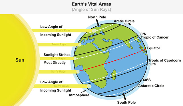

In geography, latitude is the angular distance north or south of the Earth's equator. Lines of latitude are circles that run parallel to the equator and are used to measure the distance between a point on Earth and the equator.
The equator is the 0° latitude line, and it is the longest line of latitude. The North Pole is the 90° north latitude line, and the South Pole is the 90° south latitude line.
Latitude is measured in degrees, and each degree of latitude is equal to about 69 miles (111 kilometres).
Latitude is important for determining the climate of a place. Places that are near the equator have a warm climate, while places that are near the poles have a cold climate.
Latitude is also important for navigation. Sailors and pilots use latitude to find their way around the world.
The ship's latitude was 40 degrees north.

Noun: Latitude is a measure of the distance north or south of the Earth's equator. It is measured in degrees.
Adjective: Latitude is an adjective that describes something that is related to latitude. For example, a latitude line is a line of latitude.
Verb: To latitude is to measure the latitude of something. For example, to latitude, a ship is to measure its latitude using a sextant.
The word "latitude" comes from the Latin word "latitudo", which means "breadth". It was first used in English in the 14th century.
The Latin word "latitudo" is made up of two parts:
"latus", which means "broad".
"-tudo", which is a suffix that means "state or condition of".
What is latitude measured in?
Question:
Describe the concept of latitude and its significance in geography and Earth's navigation. Explain how latitude lines are measured and their role in determining climate patterns. Provide examples of how latitude influences the distribution of ecosystems around the world.
Answer:
Latitude is a geographic coordinate that measures a location's distance north or south of the equator, which is considered the reference point at 0 degrees latitude. It plays a crucial role in understanding Earth's geography and navigation. Latitude lines, also known as parallels, run horizontally around the Earth, with each degree representing approximately 111 kilometres.
Latitude lines are measured using instruments like astrolabes, sextants, and global positioning systems (GPS). These lines aid in navigation and determine a location's proximity to the poles. Additionally, latitude strongly influences climate patterns. Areas closer to the equator experience a tropical climate due to the direct angle of sunlight and consistent heating. In contrast, regions farther from the equator have temperate or polar climates due to the oblique angle of sunlight and varying solar intensity.
Ecosystem distribution is also significantly impacted by latitude. The diverse ecosystems at different latitudes result in distinct biomes, such as rainforests near the equator, temperate forests at mid-latitudes, and tundra near the poles. The length and intensity of daylight, temperature gradients, and prevailing wind patterns at different latitudes shape these ecosystems.
In conclusion, latitude is a fundamental geographic concept with wide-ranging implications. It influences navigation, climate, and ecosystem distribution, illustrating its vital role in understanding Earth's geography and natural processes.